Understanding how to read a PIREP is a fundamental skill for every pilot, from student aviators to seasoned professionals. While automated systems like METARs and TAFs provide essential data, a PIREP, or Pilot Report, offers a unique perspective from someone actually flying in the environment. These reports bridge the gap between theoretical forecasts and real world flight conditions, especially when combined with professional flight training and aviation education resources that teach pilots how to interpret real-time weather safely.
A PIREP serves as a firsthand account of meteorological phenomena such as turbulence, icing, and cloud tops. Because these reports are generated by pilots for pilots, they often contain nuances that ground based sensors might miss. Learning to decode this information quickly allows you to maintain high levels of situational awareness and make informed decisions during your flight.
Every PIREP follows a standardized format to ensure clarity and rapid dissemination across the aviation community. The report begins with a header that identifies whether the message is routine or urgent. This distinction is vital because it immediately alerts other pilots and air traffic controllers to potentially hazardous conditions that may require a change in flight plans.
The body of the report contains specific data fields, each preceded by a slash and a two letter identifier. These fields provide details on location, time, altitude, and the actual weather observation. By breaking down each segment, you can visualize the sky ahead of you and anticipate changes in the atmosphere before they affect your specific aircraft performance.
There are two primary categories of Pilot Reports that you will encounter. A Routine PIREP is marked with the letters UA and contains weather observations that are not hazardous. These provide a link between the forecast and actual conditions, helping pilots confirm that their flight path remains clear and comfortable as originally planned.
An Urgent PIREP is designated as UUA and signifies potentially hazardous conditions. This includes phenomena like severe icing, extreme turbulence, or volcanic ash. When you encounter a UUA, it is a signal to pay immediate attention, as the safety of your flight or a high performance aircraft like a Cessna 590 could be at risk.
The location field, identified by the /OV tag, tells you exactly where the weather was encountered. This is usually expressed in relation to a three letter NAVAID identifier or a specific airport. Pilots often report their position as a radial and distance from a VOR, such as /OV SAV 180020, meaning twenty miles south of Savannah.
In some cases, the location may be reported as a route segment between two points. This is particularly helpful for identifying the leading edge of a weather front or a localized area of turbulence. Understanding the /OV field ensures you can plot the reported conditions accurately on your sectional chart or electronic flight bag for better navigation.
The /TM field indicates the time of the observation in Coordinated Universal Time or Zulu time. It is crucial to check the timestamp because weather can change rapidly. A report from several hours ago might no longer be accurate if a fast moving storm system has already passed through the area during your flight.
Following the time is the /FL flight level field, which indicates the altitude where the weather was encountered. This is reported in three digits representing hundreds of feet. For example, /FL065 means 6,500 feet. Knowing the specific altitude allows you to request a different flight level to avoid uncomfortable or dangerous conditions reported by others.
UA/UUA: Identifies the report as Routine or Urgent. Urgent reports cover hazards like tornadoes, hail, or severe icing.
/OV: Location relative to a fix, VOR, or airport.
/TM: Time of the observation in four digits (UTC).
/FL: Altitude or Flight Level in hundreds of feet MSL.
/TP: Aircraft Type, which is essential for scaling the intensity of turbulence or icing to your own plane.
/SK: Sky Cover, including cloud amount and height of bases and tops.
/WX: Weather and Flight Visibility reported in statute miles.
/TA: Air Temperature in Celsius, critical for identifying icing potential.
/WV: Wind Velocity and direction in six digits.
/TB: Turbulence intensity and type (e.g., LGT, MDT, SVR).
/IC: Icing intensity and type (e.g., RIME, CLR, MX).
/RM: Remarks for any free form text and additional hazardous details.
The /SK field describes the sky condition, including the amount of cloud cover and the height of the bases and tops. Abbreviations like OVC for overcast, BKN for broken, and SCT for scattered are used here. This data is essential for pilots flying under visual flight rules who need to remain clear of clouds.
Knowing the cloud tops is especially beneficial for pilots seeking a smoother ride above a layer. If a PIREP indicates /SK TOP085, you know that climbing to 9,000 feet will likely put you in clear air. This field provides the vertical map needed to find the most comfortable and efficient cruising altitude for your specific flight.
The /WX tag provides information on flight visibility and any active weather phenomena like rain, snow, or haze. Visibility is usually reported first in statute miles. Standard METAR codes are used here, such as RA for rain or TS for thunderstorms, providing a clear picture of the environment at your altitude.
This field allows you to anticipate restrictions to visibility before they become a factor. If multiple pilots are reporting decreasing visibility along your route, it acts as a proactive warning to check your fuel reserves and look for potential alternate airports. Accuracy in reading /WX can prevent unintended encounters with deteriorating flight conditions.
Temperature is reported in the /TA field in degrees Celsius. If the temperature is below zero, it is preceded by an M for minus. Temperature is a primary indicator of potential icing conditions. When visible moisture is present and the /TA shows a subzero reading, the risk for structural icing increases significantly.
Monitoring the temperature helps you understand why icing might be occurring at specific altitudes. If you encounter ice, you can use the temperature data from other PIREPs to find a warmer layer where the ice may stop accumulating. This tactical use of temperature data is a hallmark of professional and safe piloting.
The /TB and /IC fields describe turbulence and icing, respectively. These are often the most sought after pieces of information in a PIREP. Both are described using standardized intensity terms: light, moderate, severe, and extreme. The type of icing, such as rime or clear, is also included to help you understand the hazard.
These observations are subjective but invaluable. Pilots use these fields to verify if the actual conditions match the preflight briefing. If you are flying into an area with reported moderate icing, you should already have a diversion plan in place. These fields provide the real time data needed to execute those safety plans effectively.
The /RM field is where pilots can add free form text to clarify their observations. This section often contains the most descriptive details, such as the location of low level wind shear or the specific behavior of a storm cell. It is the place for any information that does not fit neatly into the other standardized tags.
Remarks can also include pilot intent, such as requesting higher or returning to airport. Reading the /RM section provides context that can help you understand the severity of the weather. It is the human element of the report that adds depth to the raw data provided in the previous sections of the PIREP.
Once you understand how to read a PIREP, you should feel confident enough to submit one yourself. You can provide a report to any air traffic control facility or Flight Service Station via radio. You do not need to use perfect code; plain English is perfectly acceptable as long as the information is clear.
By sharing what you see, you contribute to a safer environment for everyone in the sky. Your observation could be the one that helps another pilot avoid a dangerous thunderstorm or a pocket of severe turbulence. This community based exchange of information is one of the pillars of modern aviation safety and professionalism.
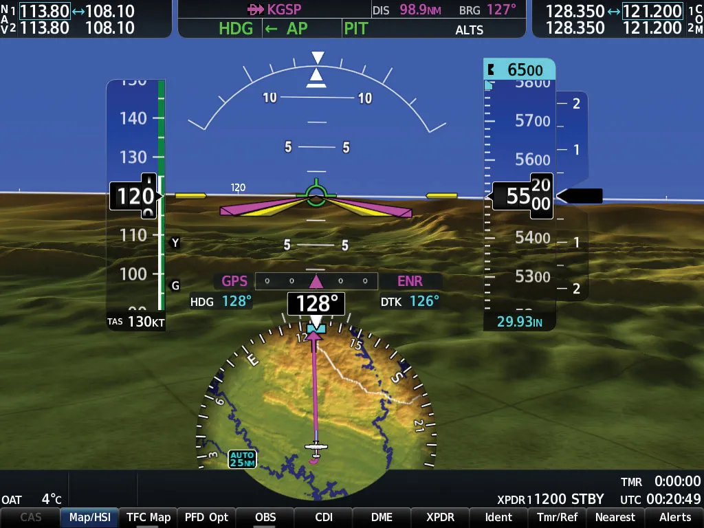
Modern avionics and electronic flight bags have made it easier than ever to access PIREPs in the cockpit. Digital displays can plot reports as icons on your moving map, allowing you to see exactly where hazards are located. This visual representation makes decoding the data much faster during high workload phases of flight. Pilots interested in experiencing real cockpit conditions firsthand often benefit from a hands-on discovery flight experience, where real-time weather interpretation becomes part of the learning process.
However, even with advanced technology, you must still understand the underlying code. Digital systems can sometimes fail or provide delayed information. Being able to listen to a PIREP over the radio and decode it mentally remains a vital skill for every pilot.
Becoming proficient at reading PIREPs takes practice and repetition. Make it a habit to look at all available reports during your preflight planning, even if the weather looks clear. Over time, the abbreviations and formats will become second nature, allowing you to focus more on flying and less on translating the data.
The sky is a dynamic and ever changing environment. By mastering the language of PIREPs, you gain the ability to listen to what the atmosphere is telling you through the eyes of other aviators. This connection to the wider aviation community is what keeps us safe and prepared for whatever challenges the weather presents.
Navigating the complexities of aviation weather is a lifelong learning process that requires the right mentorship and resources. Whether you are a student pilot just beginning or an experienced aviator looking to sharpen your skills, having professional support can make a significant difference. Understanding the tools available to you is the first step toward a safer flight.
If you are ready to take your aviation knowledge further and master the technical details of flight, reach out to Savannah Aviation at (912) 662-5048. Our team is dedicated to providing high quality training and guidance for all your aviation questions and goals, supported by professional aircraft maintenance and safety services that keep pilots and aircraft operating at peak reliability.
Request a personalized discovery flight and experience how professional instruction and careful preparation make learning to fly exciting and rewarding. Our team guides every step to help you build skills safely and confidently.
.webp)


.webp)